Snow forecast as temperatures drop to -5C in Yorkshire


The snow and ice is set to sweep over Scotland and arrive in North and West Yorkshire later today and through the night.
And drivers can expect frozen windscreens first thing tomorrow as temperatures fall to -5C during what forecasters are predicting will be a sustained cold spell across the UK.
Advertisement
Hide AdAdvertisement
Hide AdThe Met Office warning states: "A spell of rain, quickly turning to sleet and snow, will move southeast across the UK on Monday night and Tuesday, gradually weakening across England and Wales.
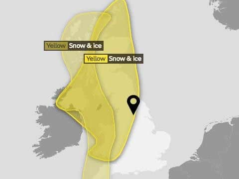
"Some roads and railways may be affected with longer journey times by road, bus and train services. As rain, sleet and snow clears Northern Ireland and Scotland overnight Monday, ice may form on some untreated roads, pavements and cycle paths."
The full forecast for Yorkshire:
Today:
Cold and crisp, with light winds, a few wintry showers and some sunny spells. A few icy stretches are possible on untreated surfaces early on, as well as some local slight snow accumulation, before showers largely fade away later. Maximum temperature 4C.

Tonight:
Becoming clear and very cold during the evening, with temperatures falling away. Becoming cloudier in the northwest to end the night, with a little snow here by dawn. Minimum temperature -5C.
Tuesday:
Advertisement
Hide AdAdvertisement
Hide AdSoon becoming generally cloudy, with some snow during the morning, leading to slight accumulations. Cold throughout, but becoming drier with sunny spells from the west later, on a strengthening wind. Maximum temperature 3C.
Outlook for Wednesday to Friday:
Cold and clear with sunshine Wednesday, ahead of a cloudier and breezier Thursday with a little rain and sleet. Friday starting similar, becoming brighter later but with isolated snow showers.